Thursday, December 15, 2011

Past-Present-Future

100 million years ago…
Ok, it’s 105 Million Years Ago (mya).  I theorize that Fairbanks, Alaska was located on an oceanfront view—the North Pacific Ocean.   Fairbanks is sitting, with no change in hemisphere, staying within the polar latitudes.  One big difference between Fairbanks of today and Fairbanks 105 mya is that today, it only has the Continental Polar (cP) air mass impacting the area.  105 mya Fairbanks was presented with both cP and the Maritime Polar (mP) air mass.  The reasoning for the two air masses in the past, is that the location of Fairbanks was closer to the West Coast than it’s current inland location.  Those air masses are the Aleutian low and the Siberian High.
The Aleutian low pressure system carries with it strong cyclones.  The cyclones form because they have the cold frigid air coming down over the trough of warm ocean water.  These cyclones, being stronger in winter and weaker in summer, form over the water and will intensify until they hit land.  At that time, they will start to loose their intensity.  A great example of a strong vortex cyclone hit Nome a month ago titled ‘super storm’ contained winds up to 90 mph, and 6-9 foot storm surges. 105 mya, when Fairbanks was closer to the coast, it would feel the full impact of these cyclones.  Today, with Fairbanks being further inland, and surrounded by three mountain ranges, the storms are much weaker due to orographic uplift.  The Siberian High starts as a cP but then rows over the Pacific Ocean and becomes a mP.  When the mP air mass hits the continent and the mountain ranges, it causes orographic uplift and can produce heavy precipitation (snow or rain), amounting to moisture to the area for all seasons.
One similarity of the past and present Fairbanks is that it sits under low sun angles.  The lack of radiation from the sun in association with the reflection from the ice and snow packs leads to low average temperatures.  Since, the way the sun-rays smile on Fairbanks the seasons will be cool, and dry.   

According to the Köppen-Geiger climate classification Fairbanks today resides in the climate zone Dfc compared to being in the Dfc and on the cusp of ET millions of years ago.  Both of these climate zones will have the same characteristics of the subarctic climate.  Fairbanks of the past, however, sat on the coast like present day Nome and because of this, would have had warmer temperatures.  One can see, illustrated on the climographs, the difference of temperature is warmer for Fairbanks being on the coast than inland on the continent.

Fairbanks-100 mya
Fairbanks- present day

The temperature in the sub polar arctic have cool, short summers, and won’t have more than four months with temperatures above the 50’s; and long cold winters.  100 mya the averages for temperature and precipitation were:

Jan
Feb
March
April
May
June
Average high in °F
13
14
18
27
43
54
Average low in °F
-2
-2
1
12
31
41
Av. precipitation - inch
0.91
0.75
0.59
0.67
0.75
1.14


July
Aug
Sep
Oct
Nov
Dec
Average high in °F
59
56
49
34
23
16
Average low in °F
47
45
37
23
11
1
Av. precipitation - inch
2.17
3.23
2.52
1.57
1.3
1.02


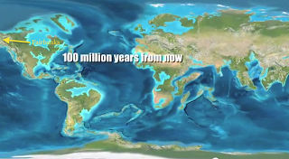
Now, when the plates moved one would see, present day Fairbanks has become an inland continental city.  Well, it stays like that even into the future 100 million years (myf). 
In the future Fairbanks will move down in latitude and still be affected by the cP air mass.  This move of the plates changes the climate zone of Fairbanks.  Fairbanks being relocated further south in latitude will warm up the city and allow more precipitation.  The city will be considered in the CSb zone.  This zone will bring Fairbanks a climate very much welcomed.  It will have warm, dry summers and cool, wet winters. The climographs compare the warm up with the shift in location between the present and the past.
Fairbanks-present day
Fairbanks- Future 100 myf
I am also taking into consideration climates all around the Earth will have increased temperature because there are less glaciers at the pole, less reflection of solar radiation. 

The average temperature and precipitation in the future will be:

Jan
Feb
March
April
May
June
Average high in °F
33
39
49
58
66
74
Average low in °F
22
26
30
35
43
49
Av. precipitation - inch
1.81
1.5
1.54
1.3
1.61
1.18


July
Aug
Sep
Oct
Nov
Dec
Average high in °F
83
83
73
58
41
33
Average low in °F
55
55
46
36
29
22
Av. precipitation - inch
0.75
0.67
0.75
1.06
2.24
2.24

Cities used:
Images:
http://www.youtube.com/watch?v=jOzh5YuLVb4
http://www.richhoffmanclass.com/chapter8.htm
http://www.islandnet.com/~see/weather/almanac/arc2006/alm06jan.htm
http://www.usclimatedata.com/climate.php?location=USAK0170
http://www.usclimatedata.com/climate.php?location=USAK0083
http://www.youtube.com/watch?v=uGcDed4xVD4&feature=related&fb_source=message
http://www.usclimatedata.com/climate.php?location=USWA0422


Information:
"Find The Atmosphere : An Introduction to Meteorology 11th Edition 2009 Lutgens, Frederick K.;Tarbuck, Edward J.;Tasa, Dennis 0321587332 9780321587336 - Direct Textbook." Shop for Used Textbooks, New Textbooks, Rental Textbooks & EBooks: Direct Textbook. Web. Dec. 2011. <http://www.directtextbook.com/prices/9780321587336>.


Tuesday, December 6, 2011

Climate Differences

Foothills on three sides surround Springfield, Missouri, similar to Fairbanks. But, mainly it is as flat as a pancake. Springfield, oppose to Fairbanks has a variety of seasons; winter, spring, fall, summer.


Photos top to bottom:
tp://www.nixalawnservice.com/winter/our-top-5-winter-activities/
http://www.springfieldmo.org/places-to-stay/cat/9/menu/125/client/69432
http://hoffsarah.blogspot.com/2010_06_01_archive.html                       
http://www.springfieldmo.org/discover 


The winters are cool to cold and often dry. However, having the west side of the city exposed, the Northwest winds triumph by bringing with snow accumulation yielding much precipitation during this season. The season of spring is another active time for Springfield. During the spring, they tend to get tons of rain; this is also the time when the count for Tornados begins.[1]


The average temperature is 56F with the warmest average temperature being 90F in the summer months of July and August. While, the month of January holds to be the coldest at an average of 23F. Springfield, throughout the year, will find they get at least 106 days of some type of precipitation. Of course, this can come in the form of messy sleet, tears of rain, Frosty’s makings, or an insurance companies love—hail.[2]
http://www.climatetemp.info/usa/springfield-missouri.html


Springfield being in the center of Ozark Plateau combats wind funnels. The wind tunnels coming out from the southeast and are forced up against the winds in the North between the ridges. These winds can be predicted because they are a natural phenomenon.
[3]
http://www.wdtb.noaa.gov/courses/winterawoc/microclimates/SGF/IC%2043e_SGF_funneling-Boxell_20110405.pdf
While Fairbanks located in the high-latitude zone, the Köppen-Geiger climate classification locates Springfield in the mid-latitude climates. This latitude is known as humid with no dry seasons, and hot summers.[4]
http://printable-maps.blogspot.com/2008/09/climate-maps-united-states-and-canada.html

[1] "Climate of Missouri." Wikipedia, the Free Encyclopedia. Web. Dec. 2011. <http://en.wikipedia.org/wiki/Missouri_climate>.
[2] "Springfield, Missouri Climate Information - ClimateTemp.info, Making Sense of Average Monthly Temperature & Weather Data with Detailed Climate Graphs That Portray Average Rainfall & Sunshine Hours." World Weather and Climate Graphs, Average Climate Charts, Guide to Precipitation, Temperatures, Best, Friendly, Holiday Climate. Web. 06 Dec. 2011. <http://www.climatetemp.info/usa/springfield-missouri.html>.

[3]http://www.wdtb.noaa.gov/courses/winterawoc/microclimates/SGF/IC%2043e_SGF_funneling-Boxell_20110405.pdf

[4]http://www.blueplanetbiomes.org/climate.htm

Wednesday, November 30, 2011

Time for Climate

Given that Alaska has a high location latitude, the territory is familiar to severe seasonal variability.  This environment leads to the warmer weather in the summer and frigid cold winters to keep ‘Frosty the Snowman’ around longer than here in Denver.  These conditions occur when Fairbanks has clear skies and unruffled winds—especially due to the prime location in the valley. Fairbanks sitting in the Tanana Valley surrounded on by the Alaska, Kuskokwim, and the Yukon-Tanana Uplands mountain Ranges. “Almost nowhere on Earth are surface-based temperature inversions stronger than in the Interior of Alaska.”[1]
http://www.greatlandofalaska.com/reference/ranges.html#alaska
The cold continental polar air mass troughs down the slopes to the valley base, where it gets trapped.  Once this air is trapped in the valley base it circulates around the residing community with freezing temperatures—burr.  In the winters, the mean temperature average is slightly below freezing.  Also, during the winter because of this inverse created by being in the valley produces ice fog.  The ice fog is a dense layer of suspended ice crystals, caused by gases being emitted from the surrounding urban island.[2]
*(Web Cams can be seen through the links at the top of RAFscience blog)

Under the Köppen-Geiger, Fairbanks, is considered part of the subarctic climate.[3]  This climate covers an extensive area; western Alaska to the Newfoundland, and Norway to the Pacific coast of Russia.  The subartic climate may also be referred by as the taiga.  In the taiga, coniferous trees are native, but, not too many other plants.  In the summer the residents will encounter millions of insects though, and birds migrate there every year.[4]
http://www.blueplanetbiomes.org/taiga.htm

[1]Shulski, Martha , and Michael Mogil. "Alaska's Climate and Weather."Weatherwise Magazine. N.p., n.d. Web. 29 Nov. 2011. <hhttp://www.weatherwise.org/Archives/Back%20Issues/2009/January-February%202009/full-shulski-mogil.html>.
[2] "The Interior." Alaska Climate Research Center. N.p., n.d. Web. 30 Nov. 2011. <http://climate.gi.alaska.edu/Stations/I
[3]Lutgens, Frederick K., Edward J. Tarbuck, and Dennis Tasa. "World Climate" The Atmosphere: an Introduction to Meteorology. 11th ed. New York: Prentice Hall, 2010. 441. Print.
[4]"Taiga Biomes." Blue Planet Biomes. N.p., n.d. Web. 30 Nov. 2011. <http://www.blueplanetbiomes.org/taiga.htm>.


Sunday, November 6, 2011

Springfield, Missouri vs. Fairbanks, Alaska

Springfield, Missouri located near the Ozark Mountains and front row tickets to the action from ‘Tornado Alley’. The topography of this city causes similarities and differences in weather next to Fairbanks, Alaska.  They both share the dry, cold continental polar (cP) air mass, for Springfield it comes down from the north in the winter.  The difference between the cities lies in the collision of the second air mass.  Fairbanks receives a cold, moist air-mass from the Aleutian Low causing a warm occlude front creating the precipitation to form in snow; while Springfield collides with the Bermuda Azores High. The Bermuda Azores High coming in from the Gulf of Mexico has a following of warm, moist air causing a cold occlude front. [1]  The warm air from the maritime tropic (mP) over taken by the colder air of the continent polar (cP); causing the warm parcels to freeze--result--ice storms. [2] 
photo by Weather Journal
http://weatherjournalandmisc.owlinc.org/    

photo by Alan Burkhart
http://alanburkhart.blogspot.com/2009/01/images-from-missouri-ice-storm.html
Springfield, affected by two different types of air masses; the Bermuda Azores High and the Continental Yukon High can make for thunderstorms in the Spring and Summer.   From these storms, a super cell thunderstorm can grow which creates Tornado’s.  The super cell from which the Tornado comes from must be very unstable and consist of the cold, dry polar air (cP) arguing with the warm, moist tropic air (mT). Now, lets imagine a pencil (cold air) rolling across a flat surface. As the pencil is still rolling something slowly starts to lift the pencil into a vertical direction (uplift) while still in motion.  The air mass when colliding starts to swirl and form funnels.  This funnel begins to spin faster and creates a low-pressure area, this in turns gathers more air from the outside (possibly debris) into it; the creation of a Tornado.[3]
diagram from NESTA

photo by Dick Gowan
http://stackedplates.blogspot.com/2009/07/storm-photos-of-day.html


[1]Morvay, Megan, weatherandclimate3232@wordpress.com
[2]Lutgens, Frederick K., Edward J. Tarbuck, and Dennis Tasa. "Air Masses." The Atmosphere: an Introduction to Meteorology. 11th ed. New York: Prentice Hall, 2010. 249. Print.
[3]"Tornado Formation." Windows to the Universe. National Earth Science Teachers Association (NESTA). Web. <http://www.windows2universe.org/earth/Atmosphere/tornado/formation.html>.


Monday, October 24, 2011

Air Pressure and Fronts

The air masses that affect Fairbanks, Alaska is the maritime (m) polar (P) or mP, and the continental (c) polar (P) or cP.  The mP drops by in the winter, blowing cool, humid air from the ocean into the state.  This air mass causes a warm-type occluded front.  The warm-type occluded front carries with it cool air from the Pacific Ocean gently nudging the cold air originating over the continent.  This pushes the warm air aloft and forms precipitation.[1]  There is also an air mass that originates over the state of Alaska called the continental polar (cP). This air mass is dry, and cold.  It forms at the end of winter when it packs its bags full of cold, dry weather and travels out of Alaska to visit the United States along the Rockies.

The Aleutian Low is a semi-permanent pressure system near the Aleutian Islands. Its crazy intensity in the winter creates strong traveling cyclones.  These types of storms cause cold winds to roll down from the Arctic poles and circulate over the continent—burr.  In a ‘positive phase’ oscillation, high pressure moves ocean storms farther towards the arctic providing a messy,wet system over the State of Alaska.[2]

Surface maps, similar to below, illustrated a cold and occluded front taking place around Alaska.  They will be encountering a cold front coming in from the north heading south.  Also, on Sunday the 30th  the beginning occlusion cyclonic circulation over the Aleutian Islands will be moving northeast into the state bringing precipitation.


(updating images provided by Mountain Weather http://www.mountainweather.com/index.php?page=alaska_weather)


[1] Lutgens, Frederick K., Edward J. Tarbuck, and Dennis Tasa. "Air Masses." The Atmosphere: an Introduction to Meteorology. 11th ed. New York: Prentice Hall, 2010. 248. Print.

[2] The Arctic Oscillation and Arctic Weather Patterns." National Snow and Ice Data Center (NSIDC). Web. <http://nsidc.org/arcticmet/patterns/arctic_oscillation.html>.